Edit global shift and scale
Menu
This tool is accessible via the 'Edit > Edit global shift & scale' menu
Description
This tool let the user edit the 'Global Shift & Scale' of the selected entity (cloud, mesh or polyline).
See the Global Shift and Scale section for more information.
Procedure
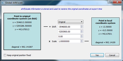
Select an entity (cloud, mesh or polyline) and start this tool. A dialog very similar to the one that CloudCompare displays when an entity with big coordinates is loaded will appear:
A numerical 'example' of the current shift and scale settings is given in the turquoises frames:
- on the left a point is expressed in the global coordinate system (along with the bounding-box diagonal length in the bottom part)
- on the right, the same point is expressed in the local coordinate system (with the equivalent bounding-box diagonal length as well)
The user can change the shift and scale values. The values in the turquoise frames are automatically updated to reflect these modifications. The modified values appear in purple or red:
When the shift and scale values are modified, then either the local coordinate system or the global coordinate system will be impacted.
Keep local coordinate system
By default, the tool will modify the global coordinate system. This way one can easily change the geo-localization of the cloud, or even simply remove them so as to save the cloud in a local coordinate system.
In this mode, no modification to the cloud currently in memory will occur. However when exported, the entity might not be in the same place as the original one.
Keep global coordinate system
It is possible to tell CloudCompare to maintain the global coordinate system unchanged. For this the user must check the 'Keep original position fixed' checkbox.
In this case the local coordinate system will be modified so as to maintain the original (global) one:
In this mode the cloud in memory will be translated. However when exported, the cloud will be in the same position as the original one (apart if other transformations have been applied of course).


