pcd file is not displayed properly

Feel free to ask any question here
Post Reply
Yujin
Posts: 3
Joined: Thu Jan 25, 2024 1:08 am

pcd file is not displayed properly

Post by Yujin »

Hello,

I am trying to create a pcd file with ouster lidar and display it, but only one solid line appears.
the screen that appears when opening the pcd file
1.png (300.38 KiB) Viewed 1670 times
I wondered if I had made a mistake when acquiring the point cloud with LIDAR, so I changed the pcd file to a txt file and opened it, but it seemed to be acquired normally.
the screen that opens the txt file
2.png (504.74 KiB) Viewed 1670 times
I don't know for what reason. Would you give me a help?

I captured the screen that appears when opening the pcd file, and the screen that opens the txt file, and attached them as images.
daniel
Site Admin
Posts: 7382
Joined: Wed Oct 13, 2010 7:34 am
Location: Grenoble, France
Contact:

Re: pcd file is not displayed properly

Post by daniel »

Well, it seems that all the points are aligned.... Would you be able to share the file with me? (admin@cloudcompare.org). So that I can check whether the issue is with the file or with the PCL library (which is in charge of loading the PCD file).
Daniel, CloudCompare admin
Yujin
Posts: 3
Joined: Thu Jan 25, 2024 1:08 am

Re: pcd file is not displayed properly

Post by Yujin »

I sent you the file by email. I'd like you to check. Thank you!

Yujin.
daniel
Site Admin
Posts: 7382
Joined: Wed Oct 13, 2010 7:34 am
Location: Grenoble, France
Contact:

Re: pcd file is not displayed properly

Post by daniel »

Thanks for the file.

So it turns out that most of the points are good (about 23.1 million of them), but the others (1.3 million) are very far and aligned. They cause the cloud to look like this very long line...

Not sure how it was generated?

Anyway, one thing you can do is select the cloud, and use the 'Tools > Segmentation > Cross section' tool.

Then click on the 'advanced' button to define a clipping box to keep only the points with coordinates close to 0 (+/-100 m for instance):
cross_section_pcd.jpg
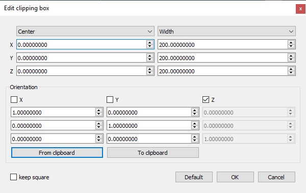
cross_section_pcd.jpg (56.53 KiB) Viewed 1514 times
Eventually click on the first red button below 'Slices' (Export selection as new entity). This will create a new cloud with only the points close to 0. You can get rid of the origin cloud and zoom on this new one (with the magnifier icon).
Daniel, CloudCompare admin
Yujin
Posts: 3
Joined: Thu Jan 25, 2024 1:08 am

Re: pcd file is not displayed properly

Post by Yujin »

I'm not sure how or why the aligned points were created.
However, when I followed the method you suggested, a new section was created and displayed well!!!
Thank you soooo much for your help.

Yujin.
Post Reply