Page 1 of 1
Contour plot option
Posted: Mon Nov 27, 2017 8:08 am
by ptisylvain
Hi Daniel,
Congratulations for this incredibly powerful software.
Since version 2.9.1, in Contour plot tab of Rasterize tool, the "ignore borders" option has disappeared.
In version 2.9 beta, with a constant SF, i was able to check the 2 options "ignore borders" and "project contours on the altitude layers" to build the general outline of the cloud.
How can i do that in 2.9.1 or 2.10 version ?
Sylvain
Re: Contour plot option
Posted: Mon Nov 27, 2017 12:20 pm
by daniel
Hum, we know use the more robust algorithm of GDAL for contour plot generation. And it has no such option...
Maybe you can set a very low altitude for the 'empty cells'? In this case you should see the 'borders' appear?
Re: Contour plot option
Posted: Mon Nov 27, 2017 2:40 pm
by ptisylvain
Thank you for your quick reply.
Maybe my question was not clear (Sorry for my poor English).
Borders appears in version 2.8.1 (but not project on the altitude layer) :
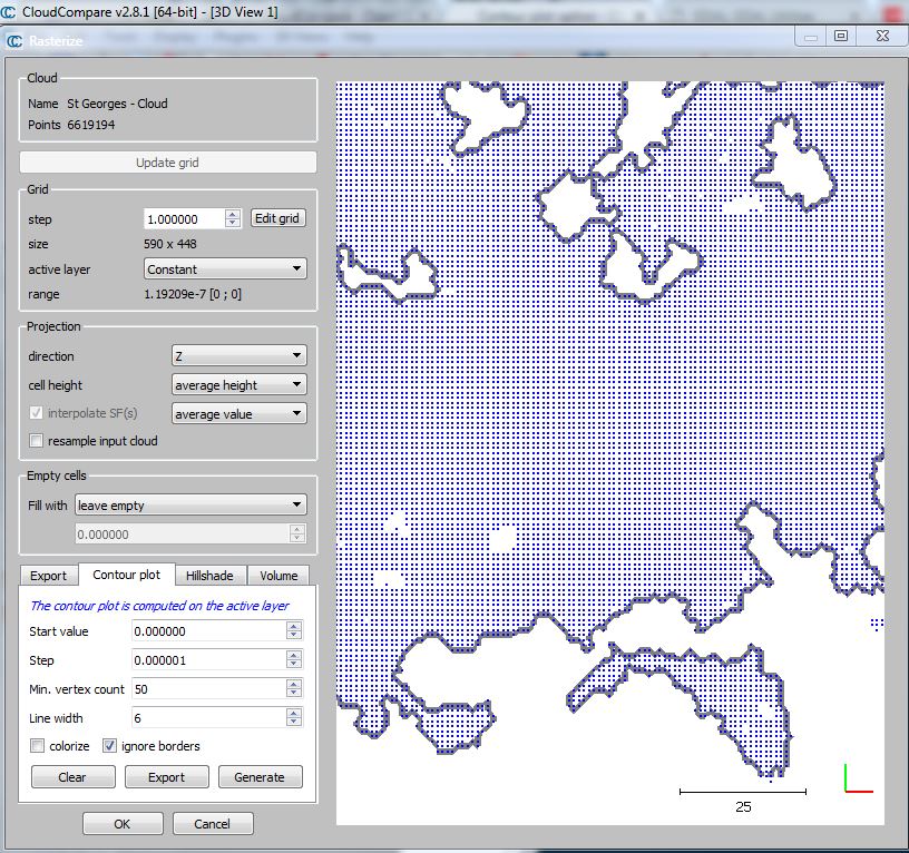
- 2.8.1.JPG (220.5 KiB) Viewed 3352 times
Impossible to reproduce borders in version 2.10 alpha (and 2.9.1) :
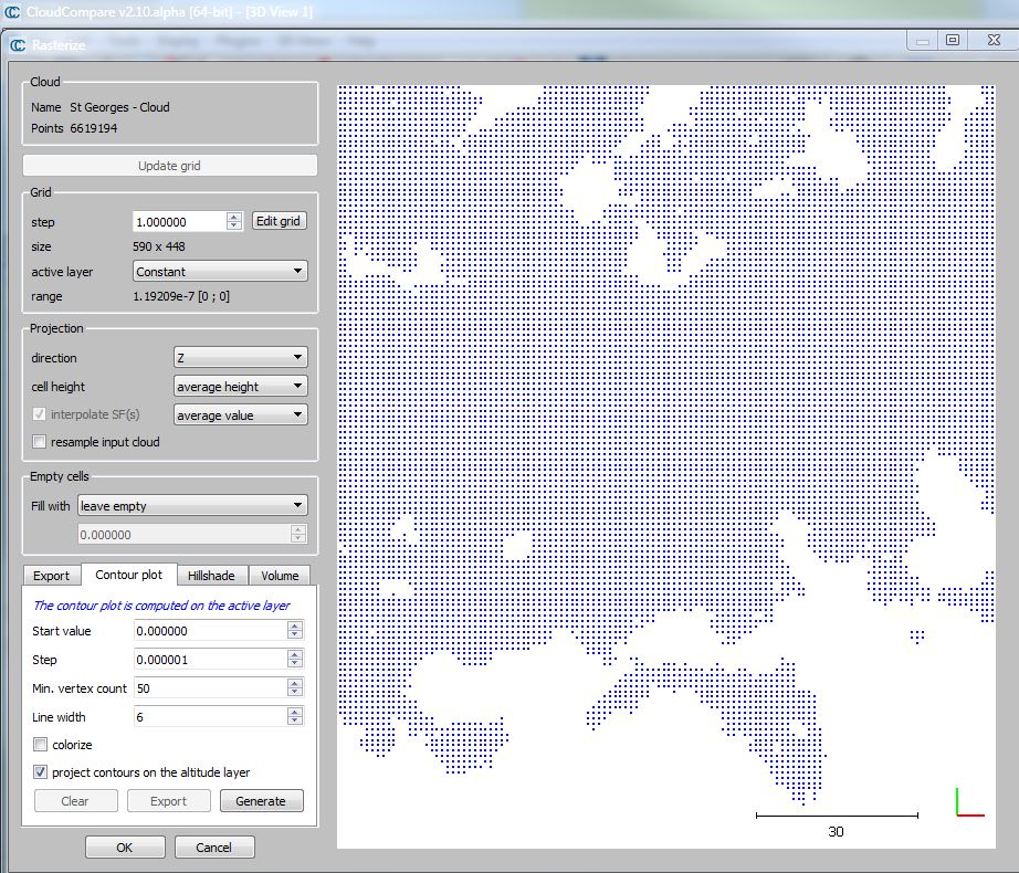
- 2.10 alpha.JPG (250.68 KiB) Viewed 3352 times
It worked in 2.9 beta (and contours was projected on the altitude layer :-) ) but I have lost this version
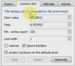
- 2.9 beta.JPG (18.84 KiB) Viewed 3352 times
As a French user, I pay my EDF bill with joy since I discovered Cloudcompare ;-)
Re: Contour plot option
Posted: Mon Nov 27, 2017 6:24 pm
by daniel
As I said, this option really has disappeared (the library we use to generate contour lines in the 2.10 version doesn't have this option).
Can you try to set the 'Empty cells' to 'custom value', set the value (below the combo-box) to something smaller than the altitudes in your raster (apparently it's all 0, so you can set it to -1 for instance) and eventually generate the contour lines?
P.S.: just to make things clear, CC was indeed initiated by EDF, but it's independent since 2009 ;). However, it's clear that they made a very nice gift to the laser scanning community by releasing the project as an open-source tool!
Re: Contour plot option
Posted: Tue Nov 28, 2017 8:23 am
by ptisylvain
Hi Daniel,
I understand now.
Unfortunately, it doesn't works directly with a 'custom value' for 'Empty cells'
But this solution does the job, partially :
- Clone the cloud
- Create constant SF with value 1 (for exemple)
- 'Set SF as coordinates' with Z axis (to obtain a flat Cloud at height 1)
- Rasterize on 'Height Grid Values' and full Empty cells with 0.5 value (for exemple). Contour plot start value 0 Step 0.5
Problem is that borders aren't project on the original altitude layer.
Re: Contour plot option
Posted: Wed Nov 29, 2017 8:50 pm
by daniel
Yes, for the projection on the altitudes, I don't see how you can do it... I guess that you'll have to stick to the old version for this particular application!
Re: Contour plot option
Posted: Thu Nov 30, 2017 6:31 pm
by ptisylvain
It works only in version 2.9 beta but I have lost it and I don't find it on the download page. How can I download 7z archive version for Windows 64 bits ?
Re: Contour plot option
Posted: Thu Nov 30, 2017 8:15 pm
by daniel
Oh you are lucky because beta versions are generally stored on the server. But I forgot to remove this one:
http://www.cloudcompare.org/release/Clo ... bin_x64.7z
Re: Contour plot option
Posted: Fri Dec 01, 2017 9:05 am
by ptisylvain
Thanks a lot !